
I came to Scotland for the very first time in 1998. It was my first backpacking trip and my rucksack was way too heavy for the frêle 22-year-old I was back then. I did manage to visit some of the highlights of Scotland, but sitting on a train towards Fort William, I spotted more experienced travellers making their way into the fierce looking highlands on foot. It looked like the apogee of freedom!
20 years later, I finally followed into their footsteps! With a much lighter backpack this time, I walked from the outskirts of Glasgow to Fort William, 96 mile or 154 km along the West Highland Way in 7 days.
From the gently undulating paths along Loch Lomond to the rugged mountain grandeur of the Scottish Highlands, this is Scotland at its best!
The West Highland way in 7 days: 10 questions before you head off
1. What is the West Highland Way?
The West Highland Way is a long-distance walk between Milngavie ( 7 miles north-west of Glasgow) and Fort William, at the foot of Ben Nevis, Britain’s tallest mountain. The route is 154km or 96 miles long.
2.How long does it take to walk the West Highland Way?
Most people walk it in 7 or 8 days. I did it in seven. It felt like a comfortable pace and gave me enough time to do small detours en route, like visiting a distillery or a nearby ancient castle. If you are planning on hiking Ben Lomond or Ben Nevis, you will obviously need more time.
Walking the West Highland Way in 7 days means you’re on average walking +/- 22km/14 miles a day. (some days shorter or longer depending on the available accommodation) I usually left around 9am and arrived at the accommodation around 4pm.
3.What level of fitness is required?
You don’t need to be able to run a marathon before walking the West Highland Way, an average level of fitness will do. If you’re used to hiking once a week for a couple of hours, you’ll manage. The terrain is generally pretty flat, even in the Highlands. The occasional steep hill is followed by a descent, so nothing too strenuous. The descents can be a bit challenging for people with knee problems, so hiking poles might come in handy.
4.What time of the year should I walk the West Highland Way?
I wouldn’t recommend walking it in winter, simply because of the possible snowfall and low temperatures. On top of that a lot of accommodation will be closed as well. April to October is the best season, the weather is generally mild enough. I went in June and was really lucky with even a few sunny days thrown in. However from June to August, you have to be aware of the dreaded Scottish midges. They are not a myth and are a real nuisance! As soon as you stand still, they will be swarming all around you. A head net is an absolute must!
Accommodation is scarce considering this is a very popular walk, so if you are going between May and September, I would advise you to book ahead!
5.What type of accommodation can I expect?
Don’t expect a massive choice if you want to stay close to the Way. I was really surprised to see how little was available. B&B’s, pub accommodation and camping are the main options. Each have their own advantages and inconveniences. B&B and pub accommodation is expensive (e.g. hard to find a double room under £75 in June) but you are guaranteed a comfortable rest and a nice breakfast. Camping is a lot cheaper, however if you are travelling in midge-season (June-September), it is almost impossible! Forget about cooking yourself a nice meal on the stove outside your tent, you’ll be swamped in no time! Camping also means you need to carry extra weight.
The Scottish Outdoor Access Code allows for wild camping along some sections of the Way. This must be done responsibly, so make sure to take away all rubbish and keep noise levels to a minimum.


6.What should I pack to walk the West Highland Way?
In a nutshell: as little as possible. The less you pack, the less you need to carry! You pass enough villages to buy provision as you go. If you’re camping, bear in mind that you’ll need to carry a tent, poles, camping equipment, … it all adds up!
Some items that shouldn’t be left out:
– waterproof gear
– hiking boots
– a head net against midges when travelling between June and September
– a first aid kit
– a pair of comfy shoes/slippers to change in for the evening
There are various companies that offer baggage transfer if you prefer walking with only a daypack.

7.What types of paths will I be walking on?
You’ll be glad to hear that you very rarely walk on a main road. The paths are a mixture of disused railway tracks, military roads and ancient drovers paths. Some sections along Loch Lomond can be a bit rough underfoot. Hiking poles might offer some more comfort on the knees during that part of the walk.

8.Is the West Highland Way signposted? Do I need a map?
You don’t really need a map of the West Highland Way, the route is easy to follow and well signposted. I had the Trailblazer WHW Guide with me, which was handy for recommendations on where to eat/stay, but I rarely had to look at it for trail guidance.
9.Do I get a certificate or stamped passport at the end of the West Highland Way?
There isn’t a “pilgrim’s passport” like the Camino de Santiago. For those who’d like a souvenir, you can buy a certificate at the end of the walk in Fort William at the Granite House. It’s quite tacky though if you ask me, but each to their own 🙂
10. I want to continue after completing the WHW, what do I do?
Wow, respect! And you’re in luck! The Great Glen Way starts right in Fort William and covers 79 miles all the way to Inverness!
Walking the West Highland Way in 7 days: the itinerary
Walking the West Highland Way in 7 days seems to be a good average, most people walk it in 6 to 8 days. It means you have time for a few detours and can enjoy the stunning landscape you pass through.
Day 1: From Milngavie to Drymen
The walk starts officially at the obelisk in Milngavie, a quiet town 7 miles north of Glasgow. Very quickly you find yourself walking on the gentle paths of the Mugdock Country Park. It’s worth doing a small detour (1/2 mile, well sign-posted) towards the ruins of Mugdock castle, a stronghold of the Graham clan, dating back to the 13th century.
You’ll pass a few lochs before walking through grasslands on a disused railway track with views over the Campsie Hills.
Don’t forget to stop at the Glengoyne whiskey distillery for a quick tipple before continuing through the hamlet of Gartness and finally into Drymen.
Distance: 12 miles/19km
Accommodation: Glenalva B&B


Day 2: From Drymen to Rowardennan
The first part of the walk is on gravel paths through open forest. You will spot Conic Hill from far away and it’s quite a steep climb to the top, but it’s so worth it!! The views over Loch Lomond are simply stunning!
A steep descent brings you to Balmaha, on the shores of Loch Lomond. From there on, the lake will be by your side for the next 2 days. You’ll walk along its banks and beaches, occasionally climbing up and down its woodlands into Rowardennan.
Distance: 14 miles/22km
Accommodation: Rowardennan Lodge Youth Hostel


Day 3: Rowardennan to Inverarnan
Today you continue hugging the eastern shores of Loch Lomond, going up and down the woodlands.
Halfway you’ll reach the Inversnaid Hotel with a nice waterfall beside it. It offers a welcoming stop for your lunch break.
The second part of the day is said to be one of the toughest stretches of the West Highland Way. I didn’t find it that hard, but the rocky path and craggy slopes can be quite demanding on the knees and ankles, so make sure you wear proper boots!
By the end of the day, you will leave Loch Lomond behind and descend into the valley of Glen Falloch towards Inverarnan.
Distance: 14 miles/22km
Accommodation: Beinglass Farm


Day 4: Inverarnan to Tyndrum
Today you start of on the stony paths of Glen Falloch, following the river. The background noise of the A82 and electricity poles might be an eyesore for some people but that stretch only lasts a short while.
After a nice section on the old military road, you’ll reach the halfway point of the West Highland Way in Crianlarich. The walk continues through conifer forest and after crossing the main road, you’ll reach wide sheep pastures offering beautiful views over the nearby mountain range.
Passing the ruins of a cemetery and the St Fillian Priory, you’ll walk through more forest, crossing the site where the battle of Dalrigh took place and where you can learn about the “lochan of the lost sword” (said to be the place where Robert the Bruce threw his sword away after the battle)
Distance: 12.5 miles/20km
Accommodation: By the Way hostel


Day 5: Tyndrum to Kinghouse / Glencoe
This is the longest part of the walk, but also one of the most remote and beautiful ones, so I didn’t really feel the distance!
You start of in the valley with beautiful mountain views, arriving at the Bridge of Orchy roughly 2 hours later.
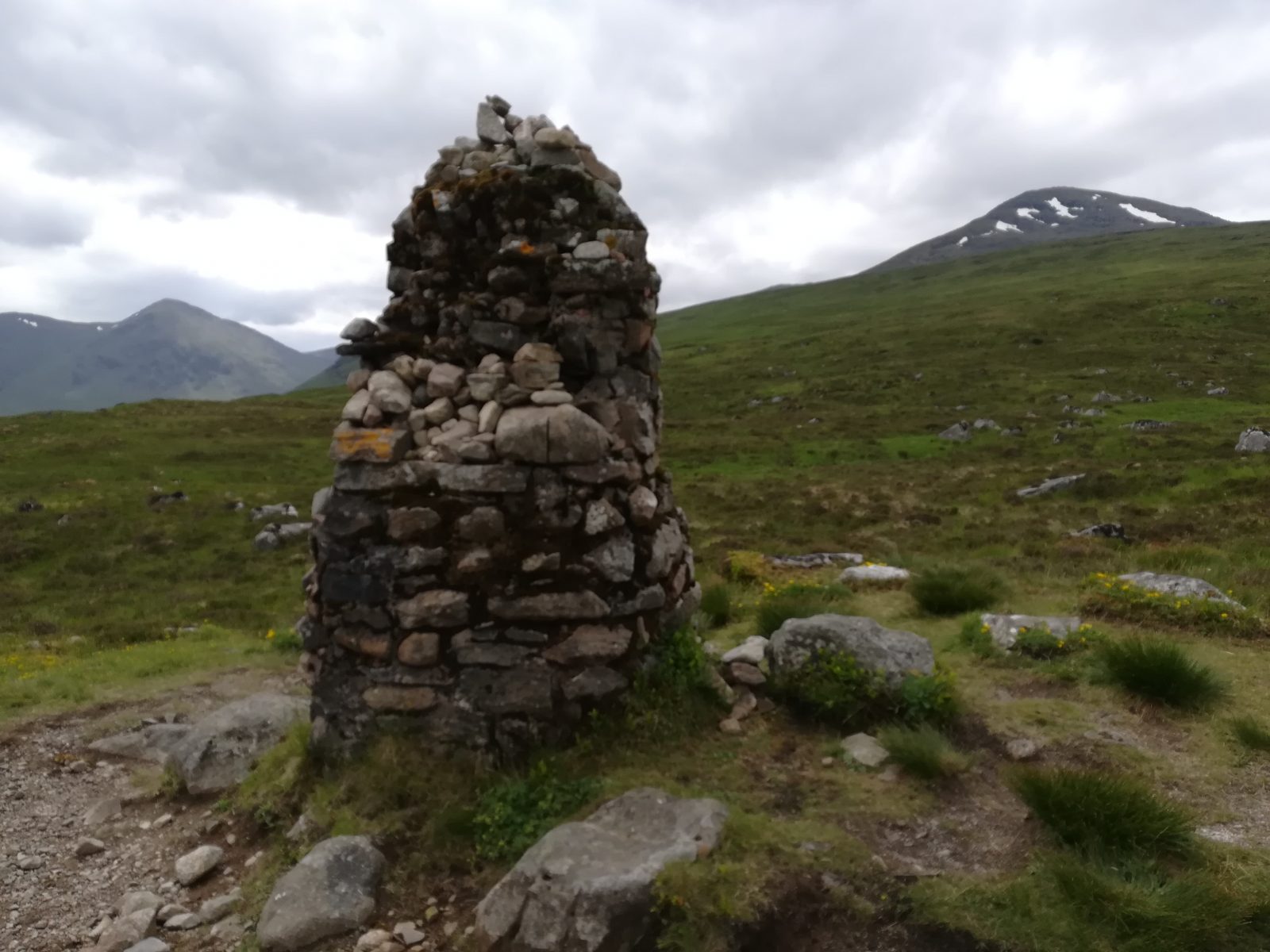
Further on, climb the little cairn for excellent views over Loch Tulla and the Blackmount mountain range.
A cobbled drove road takes you into high moorland between the vast expanse of Rannoch Moor and the Blackmount.
Today’s stretch ends at what used to be the Kingshouse hotel (re-opening in 2019) The only place to stay overnight nowadays is at the skicentre, so a lot of people opt to take a bus to nearby Glencoe.
I would highly recommend to do so, it’s a 20 minute bus ride (make sure to check the schedule before though, they are not very frequent!) through the beautiful Glencoe valley towards the picturesque village.
Distance: 20 miles/32km
Accommodation: An Darag B&B (Glencoe)


Day 6: Kingshouse to Kinlochleven
A short walk, but not to be underestimated, you are in the Scottish Highlands now! After a short stretch parallel to the busy A82, you’ll start climbing the Devil’s Staircase. The name is worse than the actual climb, but you will be thankful that you left that second pair of trousers at home, cause you’ll feel every bit of extra weight in your backpack getting to the top! The views from the top stretch all the way to the Mamores mountain range and as far as Ben Nevis (Britain’s highest mountain), absolutely stunning!
Then starts the long descent into Kinlochleven. You can see the village from far away, but the roads twists and winds down, which means it’s actually still 5 miles from the first time you spot it! The entry into Kinlochleven is very unglamorous with waterpipes and industry about, but once you’re in the village it actually turns out to be quite pleasant. Make sure you visit the Grey Mare’s Tail waterfall!
Distance: 8.5 miles/14km
Accommodation: Airbnb


Day 7: Kinlochleven to Fort Wiliam
You start your last day with a steep climb through birch trees wood and lovely views over Loch Leven. The Lairigmor (“great pass”) after that provides easier valley walking between steep and grand mountains, passing a few derelict farmhouses en route. The next stretch isn’t great: a big part of the forest has been cut down and left, making it look very “messy”. On the plus-side, you get good views over Ben Nevis!
For even better views, make sure to climb Dun Deardail, an iron-age hillfort ring, which offers 360 degree views over the whole area! (sign-posted)
A final descent on forest tracks takes you into Glen Nevis and along the road into the centre of Fort William.
Congratulations, you made it!
Distance: 14.5 miles/23 km
Accommodation: Airbnb


Have you been hiking the West Highland Way? Or any other long distance trails? Would love to hear about it!
Great content. Not yet been to Scotland, but plan on going in the summer! We may very well take this route 🙂
Thanks! Scotland is amazing! Whatever route you’re taking, the landscapes will be breathtaking! Have a great time!!